7/25/12:
I departed Natural Bridges National Monument, continuing on Route 95. The road climbed a little but cut
downsection; cliffs of Cedar Mesa Sandstone to the west, Organ Rock Formation
to the east. Then a reversal of incline,
and descent towards Lake Powell. 10:30
am; 97 degrees, and increasingly humid as I neared the reservoir. I’d never crossed Powell before, avoiding for
reasons of direction and homage to Ed Abbey (blowing the Glen Canyon Dam and thus
draining the lake is an ultimate aim in The
Monkey Wrench Gang). The dam
bothered me less now, as I’ve learned that the volcanoes at Toroweap blocked
the Canyon much longer, more frequently, and more completely than anything
humans have done. And I was curious; I’d
only glimpsed the lake before when crossing Navajo Bridge.
So
down a long hazy valley to the Hite Bridge Crossing, with a pause at Hite
Marina. The area was desolate. Lake Powell is quite low via the current
drought cycle, so there was a good 100 foot high gray-white calcareous bathtub
ring lining its margin, stark against the red rocks. The marina itself was simply human stuff –
pavement and sun-blasted structures – plopped on the alluvium. Minimal vegetation. No horizontal surfaces; the alluvium formed a
series of coalesced fans that sloped steeply down to the lake. Disorienting.
Only the ranger station looked well-maintained, promising a clean
restroom. It was. I went into the station per se – two rooms -
for relief from the heat and weather information. The ranger seemed delighted to have company,
so we chatted for a while. She was luckily
on a rotation through other parts of the National Recreation Area; a permanent
station here would be purgatory at best. The weather was going to be: hot, clear, with
monsoons in the afternoon.
Back
to 95, across the bridge, waving to the Dirty Devil River at the head of the
lake. Trixy now paid for the descent to
Hite as we climbed back up the 2000 feet we’d dropped, winding up a canyon
through the Glen Canyon Group, which here includes the Navajo Sandstone,
Kayenta Formation, and Wingate Sandstone.
Familiar names, familiar cliffs of aeolian sand.
I
was tired from the heat and accumulation of travel fatigue. Crossing the slickrock plain east of the lake
did not improve things; the rocks were pretty flat-lying in the heat. A turn west onto Route 24 at Hanksville, a
stop for the usual fluids for all parties.
Now
the geology began to get interesting. A
bit clearer away from Lake Powell, even in the midday heat. The road followed the course of the Fremont
River, which flows east from Capitol Reef and the Waterpocket Fold, joining
Muddy Creek River near Hanksville, ultimately dumping into Lake Powell. An anomalous experience to see healthy
streamflow on the Plateau. Trixy and I
travelled west through a series of valleys, cut in the Entrada Sandstone
(narrow), Morrison Formation (wide – lots of shale), Dakota Sandstone (narrow),
Tununk Shale (wide), then I lost track of the stratigraphy, looked more at the
scenery and paid attention to driving safely in the informal caravan I was
leading. Sigh, I was back onto the
tourist route, and some drivers required more speed than I wanted. I stopped and let a series of rentals pass me
at autobahn speed.
The
Morrison Formation was quite a bit thicker here than where I last saw it on the
way to Hovenweep. This much further
west, I was further into the Jurassic stream/floodplain systems that the rocks
record: more deposition here, more mud, more rock, wider valleys to drive
through. The pattern for the Tununk and
the Cretaceous rocks above it seemed similar, only here there was enough
interbedded sand to create badlands. I
suppose hoodoos were possible, but I did not see any from Route 24.
At
my courtesy stop, I had a look at the Henry Mountains, one of several larger
Tertiary intrusions which dot the Colorado Plateau. Basically, a series of large blobs of magma that
rose from wherever they formed and once they reached neutral buoyancy, forced
laterally into the surrounding sedimentary rocks. The resulting inflation created large magma domes,
and bowed up the surrounding layers. All
this took place well below the surface, but present day erosion has removed the
overlying material and exposed the igneous core. Diagrams show this called a laccolith (a
lovely archaic phrase), with a mushroom-like shape: rounded top, flat bottom,
vertical conduit reaching down to the source region. I wondered if this was accurate, especially
the flat bottom; the weight of all that magma must have caused some down-bowing. I don’t think that the basal zone of any of
the Plateau laccoliths is exposed. Well,
this was somebody else’s problem. In
other words, the answer to the question is buried.
The
road veered from its generally westward course, swinging southward. Trixy and I had been traveling gently uphill
and upsection. This now reversed as I
approached the Waterpocket Fold and Capitol Reef National Park. The former has to be the coolest geologic
name on the Colorado Plateau. Of course,
the Waterpocket is a monocline, just like the ones I’ve described before: a
more or less north-south trending structure, here on the eastern edge of the
Circle Cliffs uplift. This means that
the flexure curves up to the west, so as I travelled into it, I was declining
stratigraphically, dropping quickly through the Cretaceous and Jurassic rocks
I’d seen earlier in the morning.
Geographically,
the Waterpocket Fold forms a series of high ridges, as it brings a number of
sandstone units like the Navajo to the surface.
That’s were the place name Capitol Reef came from. These rocks create a topographic barrier, or
reef (another archaic term). One of the
blobs of Navajo in the park is supposed to resemble the US Capitol (it didn’t),
hence the name. The ridges trend
north-south, so the Park is a very elongate shape. The Fremont River carves right through the
Reef, hence Route 24. Convenient. I assume, but was never able to confirm that
“Waterpocket Fold” comes from the numerous potholes which trap rainwater in the
sandstones along the monocline.
I
stopped at the eastern park entrance - another well-maintained restroom – to
have a look down the Waterpocket. To the
south, as series of diamond-shaped ridges receded into the haze. Much more dramatic than the East Kaibab
Monocline, which was more swathed in vegetation. I knew gravel roads traversed into the Park,
both north and south. I badly wanted to
explore them; they would be both scenic and empty. But, like Toroweap, wrong vehicle, wrong
amount of time. I pushed on.
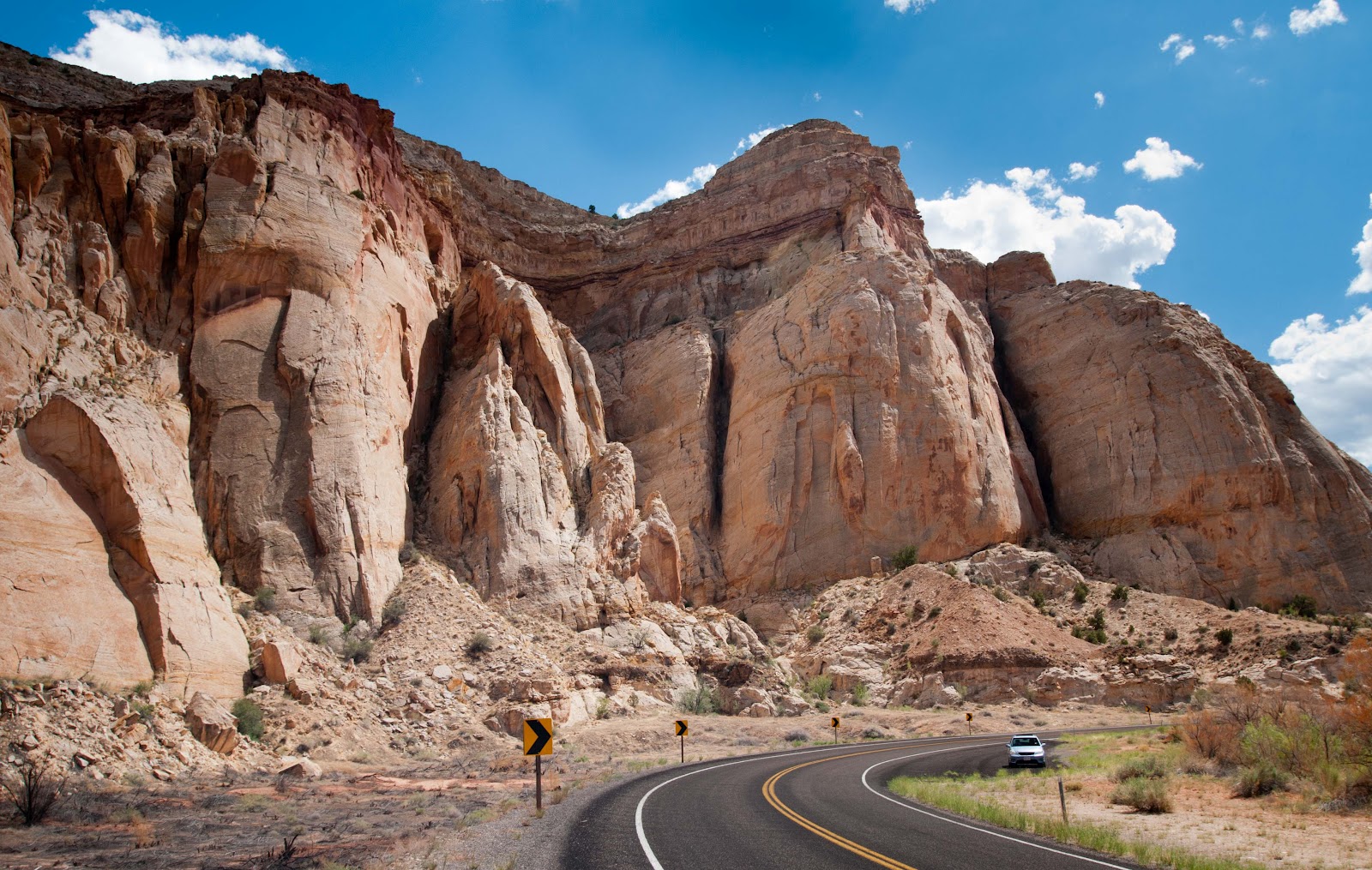 |
| Navajo Sandstone Cliffs, Rt. 12, Capitol Reef National Park, Utah |
The
core of the Waterpocket has a little floodplain along the Fremont River, which
was settled by Mormons in the 19th century. They called the area Fruita, as it became
orchard central for a few decades. A number
of settlement structures remained from that era, as well as a much newer Park VC. I planned to overnight here to provide time
to explore the paved bits of the park. I
anticipated another Park Service campground; lots of people, but enough space
and vegetation for some privacy. Wrong;
the campground was a converted orchard (I think) hence it was a gently sloping
tree-shaded bit of floodplain cut by access lanes and pull-outs, many with the
requisite hook-ups for RVs. More grass than
I’d seen in months. Well. I cruised the various lanes, looking for a
spot that was available, far from RVs, and at the end of a row. Three choices; two were waterlogged; the Fremont
River flows right by the campground, so the hosts had enthusiastically watered
the grass. The third spot looked OK; end
of a row, only the River adjacent.
Lunch,
hydration, attended by lack of motivation.
Hot morning, accumulated trip fatigue with compound interest. I drank more, and thought I can’t just sit on
this table all day, I’ve gotta explore.
So back to the VC, which was truly packed with visitors; a nexus of
Americans, Europeans, Asians. I was definitely back on the tourist route. I asked the desk ranger where I should go for
sunset photography. He told me where to
go for “solitude”; such a Park Service word, but it was a good read on his
part. He showed me some possible hikes,
which I recorded for future visits.
Afternoon,
better light to the west, so I went to the Panorama Point pullout. Lovely cliffs of Chinle Formation and Entrada
Sandstone, a good 1000 feet of relief.
The lower Entrada was fairly fine grained here, so it formed great
columns. I returned east, satisfied that
I’d captured decent images, at least as good as could be achieved without major
contemplation.
 |
| Entrada and Chinle Cliffs, Capitol Reef National Park, Utah |
 |
| (More) Entrada and Chinle Cliffs, Capitol Reef National Park, Utah |
The
ranger had recommended the Scenic Drive for sunset photography. Déjà vu; same stratigraphy, same dramatic
elevation gain; he gave me a good steer.
I picked out some good spots along the paved road, and then gave into
temptation to give Trixy a dust up by driving down Capitol Gorge. I wasn’t alone; the one lane plus gravel road
was busy with SUVs and other people stressing their passenger vehicles. The track narrowed quickly as it cut up
through the Entrada towards the Navajo Sandstone (I was transiting the
monocline). Deeper, cooler,
dustier. The Navajo seemed badly
jointed; I thought, this would be a bad place to be in a flash flood, but geez,
it’s also ripe for landslides.
Eventually, enough fractured rock, enough dust, so back to camp.
 |
| Trixy in Capitol Gorge, Capitol Reef National Park, Utah |
As
I expected, the campground was now fully populated. I had neighbors across the lane: three
campervans of Germans. Oh brother, they
were working their way through several cases of beer. Beyond my control, but I hoped they’d all
pass out before my bedtime.
Dinner
and sunset. I was early for the expected
golden light, so I waved to passing cars and found a wash where I could do taiji. The sun dropped, I took pictures, but it
wasn’t working right. I wanted to like
Capitol Reef, but had not made contact with the heart of the place: maybe the
heat, crowd, or fatigue interfered. As
pondered on this, I realized this was a matter of scale. While I’d looked at plenty of cliffs and
gorges, the lines of sight – here on the Scenic Drive, along Capitol Gorge, and
at the Panorama Point - were all compressed along the narrow valleys of the
Waterpocket Fold or constrained by high cliffs of sandstone. I couldn’t get an overall sense of what the
Park was about. Maybe a future poke down
the gravel roads and some hiking will resolve this.
 |
| Chinle Formation cliffs, approaching sunset, Capitol Reef National Park, Utah |
 |
| Entrada Sandstone cliffs, sunset, Capitol Reef National Park, Utah |
Satisfied
with sunset efforts, it was time to brave the campground and get some
sleep. Bugger, the Germans were still
drinking and now playing cards. They
weren’t the noisiest aspect of the place.
Visitors kept arriving– all French for some reason – and the hosts kept
shoehorning them in around me. Lots of
tired, annoyed voices, tents set up by vehicle headlight. I fell asleep anyway.
7/26/12:
Awake before dawn to a truly quiet campground.
There were five more camps around me than when I went to sleep. I was very tempted to play something loud on
Trixy’s audio, but went for a hike instead.
A nice two miles along the Fremont, with a nice spot for taiji at the
edge of a field. Horses for an audience.
Breakfast and departure before the
Germans were stirring.
On
to Torrey, Utah: needed ice, gas and coffee.
I cruised the main and only street.
Many bed and breakfasts, a lot with German signage. At the north end of town, a police car behind
a large sign. As I neared the vehicle,
it was clear the driver was a mannequin.
Clever. American coffee, oh well.
I’d
been contemplating on final trip destinations.
I realized that I could finish out the Plateau with quick visits to the
big name national parks of the western Grand Staircase: Bryce and Zion. I’d never been to Bryce; I figured I could
tolerate the crowds for a few hours.
Torrey
to Bryce Canyon junction: geology determined the route I took, which swung
southwest around the flank of Boulder, following drainages. Good, an opportunity to drive Route 12, which
Utah has labeled “The Journey through Time Scenic Byway”. Amusing: what road in Utah is not a journey
through time? Anyway, the road cuts
through the same Mesozoic stratigraphy I’d seen earlier on the Plateau;
familiar names, colors, and textures.
Here they’re largely within Grand Staircase Escalante National Monument,
which I’d visited with my friend Paul in 2004.
I was curious to see what had changed.
Another
friend had suggested that I shoot video with my Flip video recorder on the
trip. I’d discounted this, I’m not good
at video and editing it is hard. But
here I was on a winding scenic road with greater than 90% rock exposure. Hmmm.
I pulled out the Flip and its Gorilla tripod. I was able to mash them between the dashboard
and windscreen. Seemed pretty stable,
the view seemed about right. Back on the
road. The tripod wanted to slide. I could hold it in place. So I did not drive the next thirty miles or
so one-handed, leaning forward in my seat.
Really.
Through
Boulder, Escalante, Henrieville, Cannonville and Tropic. Businesses I recognized, but clearly newer,
spiffier outfits as well. I raced on,
wanted to get to Bryce Canyon while the sun was still to the East. Up the Gray Cliffs, and south at Bryce
Junction towards the park. From my
reading, it was clear that the most efficient and least annoying way to see
Bryce would be to park Trixy outside and use the free shuttle bus to travel around. So we stopped at Ruby’s Inn (which included a
Best Western motel, RV Park and Campground, the Cowboy’s Buffet and Steak Room,
Canyon Diner, Horseback Adventures, ATV Tours, grocery store, gas station and
garage and no doubt more). A tenfold
increase in population density; lots of Americans and Euros, and for the first
time, Asians, most of who appeared to be travelling by bus. Disoriented by all this, I took fifteen
minutes to find the shuttle stop.
So
into Bryce Canyon National Park, smiling as the shuttle bypassed the long line
of vehicles at the entrance station. A
quick stop at the VC lengthened as I tried to flow my way through the crowds;
the place as genuinely packed to the walls.
I’d expected this, but the abundance of clean people, children, and all
their shiny stuff was headache inducing.
Back
to the bus. I planned a quick hit at
Bryce, choosing not to spend a lot of time exploring among the multitudes. I rode to Inspiration Point, and took a 2 mile
rim hike north to Sunrise Point.
Bryce
Canyon is on the eastern edge of the Paunsaugunt Plateau, near the top of the
Grand Staircase. It thus exposes younger
rocks than most of what I’d seen to the east, specifically the Claron
Formation, which is essentially a thick sequence of Tertiary lake
deposits. So again, mud, but unlike the
marine muds of the Mesozoic or the swamp deposits at Bisti, these sediments
were deposited in a more arid environment and aerobic environment. In other words, the iron in them rusted,
given the strata a spectrum of colors from red through orange to light
yellow. Enough sandstone and limestone
is layered in with this stuff that – you guessed it, this is badlands
heaven.
I
literally stopped and stared when I first had a look into the Canyon, stunned
by the colors and hoodoos. This was
truly a place that images could not capture.
The scale was just right; the basin I was staring into was less than a
couple miles in width, and it was easy to comprehend the textures I was
seeing. Moreover, the bulk of Seiver
Plateau loomed to the north, so the scene also presented a sense of distance
that worked well.
 |
| Bryce Canyon National Park, Utah |
So,
to walk and try to take good snapshots.
I quickly discovered that while it was hard to not find a charming vista
over the badlands, taking a truly meaningful image was virtually
impossible. There was just too much
nuance and detail, too broad a panorama.
It would take much exploring to find the right spot to convey scale and
texture, if it’s possible. I didn’t have
the time, the trail was busy, and it was hot, even at the 8,000 feet plus
elevation where I was hiking. I tried.
 |
| Bryce Canyon National Park, Utah |
Escape
from Bryce to the sounds of an extended family arguing about logistics. Trixy looked welcome. Bryce Canyon deserved more time. It has lots of trails and much more geography
beyond the hotspots I’d limited myself to exploring. A good spot for a joint visit with Capitol
Reef. I was satisfied.
West
on Route 12, then north for a spell on Route 89 to Panguitch, finally southwest
on Route 143 towards my final stop for the day, Cedar Breaks National
Monument. The road climbed into the
Dixie National Forest. Panguitch was at
about 7,000 feet, so Trixy and I now traveled through forests of ponderosa pine
and aspen. Good bye to desert flora for
an afternoon. We passed a strange
collection of houses and trailers near Panguitch Lake, scattered on the
landscape. Winter homes? Maybe, I was near the Brian Head ski area. Felt more downtrodden than that. After gaining 4,000 feet, I reached Cedar
Breaks, another park unit I’d wanted to see for decades.
I
immediately liked this area. It was
quiet, and had the slightly ethereal feel of high elevation; I was above 11,000
feet. I found the little campground.
Lots of space with pullouts cleverly sited around a knoll, lots of flowers. I picked a site with a meadow view. No one around. I set up camp, and decided to make the 1.5
mile hike to the VC.
I
was definitely at elevation. I could
walk, but only slowly. My heart and respiration
rates were fast. The trail crossed Route
143, and I saw Cedar Breaks for the first time.
Damn.
 |
| Cedar Breaks National Monument, Utah |
A
sign I later saw at the VC said something like, if Cedar Breaks were in any
other country, it would be a national landmark.
Here, it’s just a lesser known cousin to Bryce and Zion. This is dead accurate. The badlands below me were again in the
Claron Formation, but with a western exposure.
Rather than the many amphitheatres of Bryce, here only a few embayments
of badlands, but they’re deeper and have a more highly eroded and varied suite
of hoodoos. This is the western edge of
the Colorado Plateau, so the land drops away into the Basin and Range, a good
mile of vertical relief. The Breaks were
comprehensible.
I
eventually made it to the VC, and to the official lookout for some
contemplation. There were eight other
visitors. A ranger gathered us for a
talk on trees, swelling the crowd to fourteen.
Wow, this area had bristlecone pines.
I stared more, and began to get chilly as the afternoon wore on. Back to my home-for-the-night.
As
I walked into the campground, the host approached me and said, you know, we
have hot showers. I was stunned for the
second time in the afternoon. Here, in
the highest, smallest, and most remote park I’d visited, there was hot
water. After sweating through Canyon de
Chelly, Bisti, Angel Peak, Durango, the San Juans, Hovenweep, Capitol Reef, Glen
Canyon, Natural Bridges, and Bryce, I rather needed to wash my hair. Thus refreshed, I ate, and drove back to the
lookout for sunset photography, not wanting to spoil the lack of dirt and grime
on my skin.
Sunset:
golden light on orange cliffs: enough said.
 | |
| Sunset in HDR at Cedar Breaks National Monument, Utah |
 |
| Sunset at Cedar Breaks National Monument, Utah |
The
campground host had also told me that there would be an astronomy talk after
sunset. Well, I could walk across the
campground to the amphitheater. I was in
time for the best talk I’ve ever heard in a park. The speaker was another campground host, who
was a serious astronomer. He spoke about
Saturn, which we later saw through his telescopes. It’s possible that his explanation of the
chemical mixing in the Saturnine atmosphere was too much for the kids in
attendance, but I thought it was cool.
As was the night; I was wearing five layers by the time I finished
ablutions.
 |
| Bristlecone pine, Cedar Breaks National Monument, Utah |
7/27/12:
Another pre-dawn, my last on the Colorado Plateau. I was motivated to go for a run, but getting
out of my tent and remembering that I was at altitude convinced me that a brisk
walk was a sane alternative. Four miles
and a good morning to the oldest bristlecone pine in the Monument.
On
the road; it was going to be a long day of driving, as I began my commute back
to California. Trixy and I dropped down Cedar
Canyon to Cedar City, where I finally achieved a good strong cup of coffee in
the university district and Trixy got some 87 octane fuel (rare in Utah).
Interstate
time, briefly, as twenty minutes brought me to the Kolob Canyons entrance to
Zion National Park. A western exposure,
and here I was on a hot midmorning with many miles ahead, but I had to
look. Another busy VC, but a pleasant
drive up the access road to the Kolob Canyons overlook; a series of dramatic
gorges cut into the Navajo Sandstone.
The light was truly awful.
I-15,
skirting the edge of the Colorado Plateau.
Lunch in St. George, 102 degrees, then a final drop through Virgin
Canyon into the Basin and Range. I’d completed
a grand loop in the past two weeks.
Fluids in Las Vegas, 111 degrees.
Across the border into California in late afternoon; 104 degrees at the
stateline rest stop. My camping options
decreased with distance from the Plateau, so I had decided to forgo worrying
about destination and return to a favorite spot in the Mojave National
Preserve, south of Baker. A quick look
at Kelso Dunes; any wandering among the sand would have truly been stupid (106
degrees and high albedo), so I waved and went to Mid Hills Campground.
Mid
Hills was familiar but desolate; the area burned several years ago, and little
vegetation has grown back. It was empty,
being a dry camp along a rough dirt track.
No worries, plenty of space to kick up dust while doing taiji, once the
temperature dropped below 90.
Finally,
time and enough darkness for star photography.
7/28-29/12:
The remainder of the trip was largely retracing my exfoliation route. A final stop at Carrizo Plain National
Monument to have a look at the San Andreas Fault; nice to confirm that the
pressure ridges and offset stream valleys that I show my students really
exist. A dizzy stop, 102 degrees.
Finally,
home.


